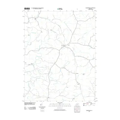
2010 Map of Sharpsburg
USGS Topo · Published 2010About this map
Sharpsburg serves as the central hub of this agricultural landscape in north-central Kentucky, where the town grid is oriented along Town Branch and the Lower East Union Rd. The surrounding terrain is defined by the winding course of Hinkston Creek, which snakes through the southern and western portions of the quadrangle. For those researching local heritage, the map identifies numerous family and community landmarks, including Crown Hill Cemetery and the more remote Carter Cemetery. Small rural settlements like Peytons and East Union are connected by a network of historic thoroughfares such as Old Iron Works Rd and Nixon Rd. The presence of Peytons Lick Church and Smith Chapel Church alongside their respective cemeteries suggests the enduring importance of these community centers in this pastoral region of Bath County during the early 21st century.
Find a feature on this map
50 named features on this map. Tap any name to fly to it.
Don’t see what you’re looking for? This feature index may not catch every label — zoom into the map to look around manually.
Map Details
Editions of this 2010 Sharpsburg Map
This is the sole edition of this map. No revisions or reprints were ever made.
Other maps of this area

1952 · Preston
USGS Topo · 1:24,000

1952 · Owingsville
USGS Topo · 1:24,000

1952 · Sharpsburg
USGS Topo · 1:24,000

1952 · Mount Sterling
USGS Topo · 1:24,000

1952 · Sherburne
USGS Topo · 1:24,000

1952 · North Middletown
USGS Topo · 1:24,000
1952 · Sideview
USGS Topo · 1:24,000

1953 · Carlisle
USGS Topo · 1:24,000

1953 · Moorefield
USGS Topo · 1:24,000

1956 · Louisville
USGS Topo · 1:250,000