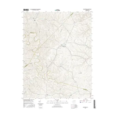
2016 Map of Sharpsburg
USGS Topo · Published 2016About this map
Sharpsburg serves as the primary hub of this central Kentucky landscape, situated where the borders of Nicholas, Bourbon, Montgomery, and Bath Counties converge. The topography is defined by the winding course of Hinkston Creek and its many tributaries, including Peytons Lick and Grassy Lick Creek. For those tracing family histories in the Bluegrass region, the map is a dense record of rural landmarks, featuring numerous small burial grounds such as Jewell Cem, Carter Cem, and Bramlett Cem. Local spiritual life is anchored by Peytons Lick Church and Smith Chapel Church. The road network, including the evocative Snake Ridge Rd and Convict Rd, connects smaller hamlets like East Union and Judy to the surrounding farmland. The presence of Flemings Pond near the center of Sharpsburg provides a localized point of interest amidst the rolling drainage basins of Somerset Cr and Bald Eagle Cr.
Find a feature on this map
64 named features on this map. Tap any name to fly to it.
Don’t see what you’re looking for? This feature index may not catch every label — zoom into the map to look around manually.
Map Details
Editions of this 2016 Sharpsburg Map
This is the sole edition of this map. No revisions or reprints were ever made.
Other maps of this area

1952 · Preston
USGS Topo · 1:24,000

1952 · Owingsville
USGS Topo · 1:24,000

1952 · Sharpsburg
USGS Topo · 1:24,000

1952 · Mount Sterling
USGS Topo · 1:24,000

1952 · Sherburne
USGS Topo · 1:24,000

1952 · North Middletown
USGS Topo · 1:24,000
1952 · Sideview
USGS Topo · 1:24,000

1953 · Carlisle
USGS Topo · 1:24,000

1953 · Moorefield
USGS Topo · 1:24,000

1956 · Louisville
USGS Topo · 1:250,000