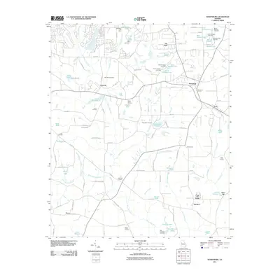
2011 Map of Sharpsburg
USGS Topo · Published 2011About this map
Sharpsburg and Turin stand as the primary hubs of this landscape, situated at the junction of rail and road corridors that define the region's development. The land is marked by an extensive network of water management features, including numerous dams such as the Chandlers Lake Dam and Clearwater Lake Dam that create a series of small, private reservoirs across the terrain. These lakes, including North Steward Lake and the North Paradise Lake system, suggest a shift from purely agricultural use toward residential and recreational land tracts.
Find a feature on this map
103 named features on this map. Tap any name to fly to it.
Don’t see what you’re looking for? This feature index may not catch every label — zoom into the map to look around manually.
Map Details
Editions of this 2011 Sharpsburg Map
This is the sole edition of this map. No revisions or reprints were ever made.
Other maps of this area

1953 · Atlanta
USGS Topo · 1:250,000

1957 · Atlanta
USGS Topo · 1:250,000

1958 · Atlanta
USGS Topo · 1:250,000

1964 · Grantville
USGS Topo · 1:24,000

1965 · Newnan South
USGS Topo · 1:24,000
1965 · Newnan North
USGS Topo · 1:24,000

1965 · Tyrone
USGS Topo · 1:24,000

1965 · Madras
USGS Topo · 1:24,000

1965 · Senoia
USGS Topo · 1:24,000

1965 · Sharpsburg
USGS Topo · 1:24,000