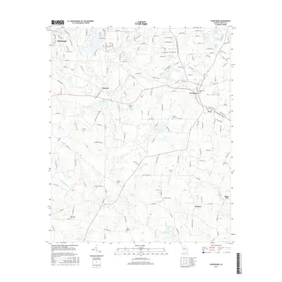
2017 Map of Sharpsburg
USGS Topo · Published 2017About this map
Sharpsburg and the surrounding Coweta County landscape are defined by a network of family-named landmarks and historical community hubs. The area is anchored by several small settlements including Turin, Raymond, and Blackjack, connected by the route of Highway 16. Local history is preserved in numerous rural burial grounds such as China Grove Cem and Mount Gilead Cem, alongside family-named water bodies like Hughie Lake and Whites Pond. Of particular interest to researchers is the presence of milling history at Elders Mill and Elders Millpond in the southeast, as well as the Sibley Millpond to the southwest. The terrain is intricately drained by White Oak Cr and Little White Oak Cr, which feed into various man-made reservoirs like Lake Raymond and Paradise Lakes, illustrating the agricultural and hydraulic development of the region during the twenty-first century.
Find a feature on this map
53 named features on this map. Tap any name to fly to it.
Don’t see what you’re looking for? This feature index may not catch every label — zoom into the map to look around manually.
Map Details
Editions of this 2017 Sharpsburg Map
This is the sole edition of this map. No revisions or reprints were ever made.
Other maps of this area

1953 · Atlanta
USGS Topo · 1:250,000

1957 · Atlanta
USGS Topo · 1:250,000

1958 · Atlanta
USGS Topo · 1:250,000

1964 · Grantville
USGS Topo · 1:24,000

1965 · Newnan South
USGS Topo · 1:24,000
1965 · Newnan North
USGS Topo · 1:24,000

1965 · Tyrone
USGS Topo · 1:24,000

1965 · Madras
USGS Topo · 1:24,000

1965 · Senoia
USGS Topo · 1:24,000

1965 · Sharpsburg
USGS Topo · 1:24,000