
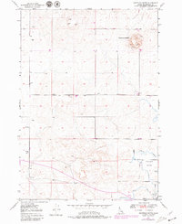
1949 Map of Shattuck Butte
USGS Topo · Published 1973About this map
Shattuck Butte stands as the prominent landmark of this southeastern Idaho landscape, overlooking a transition from high terrain to the irrigated lowlands of Oakland Valley. Mapped shortly after the war, the area shows a sophisticated network of water management essential for agriculture in this arid environment. Traces of early industrial activity are evident at a Quarry located on the eastern slopes of the butte.
Find a feature on this map
15 named features on this map. Tap any name to fly to it.
Don’t see what you’re looking for? This feature index may not catch every label — zoom into the map to look around manually.
Map Details
Editions of this 1949 Shattuck Butte Map
2 editions found
Other maps of this area

1948 · Woodville
USGS Topo · 1:24,000

1948 · Lewisville
USGS Topo · 1:24,000

1948 · Idaho Falls North
USGS Topo · 1:24,000

1948 · Idaho Falls South
USGS Topo · 1:24,000

1949 · Idaho Falls North
USGS Topo · 1:24,000

1949 · Lewisville
USGS Topo · 1:24,000

1949 · Roberts
USGS Topo · 1:62,500

1949 · Roberts
USGS Topo · 1:24,000

1950 · Shattuck Butte
USGS Topo · 1:24,000

1950 · Woodville
USGS Topo · 1:24,000