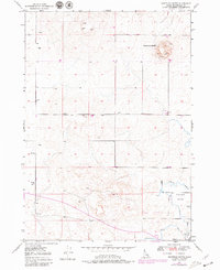
1949 Map of Shattuck Butte
USGS Topo · Published 1979About this map
Oakland Valley defines the lower-lying agricultural landscape of this Idaho quadrangle, where the engineering of water management is central to the area's development. A complex system of irrigation, including the Oakland Canal, Waste Canal, and the Martin Lateral, carves through the terrain to support local farming. The higher ground is dominated by the prominent Shattuck Butte, which shows evidence of industrial activity with several Quarry and Pit operations located on its slopes.
Find a feature on this map
11 named features on this map. Tap any name to fly to it.
Don’t see what you’re looking for? This feature index may not catch every label — zoom into the map to look around manually.
Map Details
Editions of this 1949 Shattuck Butte Map
2 editions found
Other maps of this area

1948 · Woodville
USGS Topo · 1:24,000

1948 · Lewisville
USGS Topo · 1:24,000

1948 · Idaho Falls North
USGS Topo · 1:24,000

1948 · Idaho Falls South
USGS Topo · 1:24,000

1949 · Idaho Falls North
USGS Topo · 1:24,000

1949 · Lewisville
USGS Topo · 1:24,000

1949 · Roberts
USGS Topo · 1:62,500

1949 · Roberts
USGS Topo · 1:24,000

1949 · Shattuck Butte
USGS Topo · 1:24,000

1950 · Shattuck Butte
USGS Topo · 1:24,000