
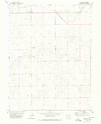
1973 Map of Shaw
USGS Topo · Published 1976About this map
Shaw serves as a lone outpost on the high plains of Eastern Colorado during the early 1970s. This survey illustrates a quiet ranching landscape defined by the drainage systems of the North Fork Arikaree River and Gordon Creek. The terrain is characterized by subtle elevation changes and expansive open space, with the county line between Washington Co and Lincoln Co cutting directly through the heart of the area. This map reveals a sparse settlement pattern typical of the region, where roads primarily follow section lines across the prairie. The geography centers on the branching tributaries of the Arikaree, which create the primary topographical variation in an otherwise uniform agricultural and grazing district.
Find a feature on this map
4 named features on this map. Tap any name to fly to it.
Don’t see what you’re looking for? This feature index may not catch every label — zoom into the map to look around manually.
Map Details
Editions of this 1973 Shaw Map
This is the sole edition of this map. No revisions or reprints were ever made.
Other maps of this area

1954 · Limon
USGS Topo · 1:250,000

1957 · Limon
USGS Topo · 1:250,000

1958 · Limon
USGS Topo · 1:250,000

1973 · Lindon NE
USGS Topo · 1:24,000

1973 · Lindon SW
USGS Topo · 1:24,000

1973 · Lindon
USGS Topo · 1:24,000

1977 · Thurman
USGS Topo · 1:24,000
1978 · Anton
USGS Topo · 1:24,000

1979 · Arriba NW
USGS Topo · 1:24,000

1979 · Flagler NW
USGS Topo · 1:24,000