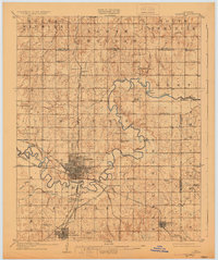
1909 Map of Shawnee
USGS Topo · Published 1930About this map
Shawnee and Tecumseh anchor this early 20th-century landscape, appearing as established hubs in a region defined by its complex river systems and intersecting rail lines. The North Canadian River meanders through the central portion of the map, crossed by historical transit points like Rock Crossing and Mc Kenzie Ford. This survey captures the era before major highway development, when the Atchison Topeka and Santa Fe RR and the Chicago Rock Island and Pacific RR were the primary arteries of commerce and travel.
Find a feature on this map
59 named features on this map. Tap any name to fly to it.
Don’t see what you’re looking for? This feature index may not catch every label — zoom into the map to look around manually.
Map Details
Editions of this 1909 Shawnee Map
Other maps of this area

1896 · Seminole and Prague
USGS Topo · 1:125,000

1898 · Purcell
USGS Topo · 1:125,000

1905 · Chandler
USGS Topo · 1:62,500

1907 · Chandler
USGS Topo · 1:62,500

1907 · Maud
USGS Topo · 1:62,500

1908 · Maud
USGS Topo · 1:62,500

1909 · Shawnee
USGS Topo · 1:62,500

1909 · Luther
USGS Topo · 1:62,500

1910 · McComb
USGS Topo · 1:62,500

1929 · Stroud
USGS Topo · 1:62,500