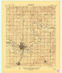
1909 Map of Shawnee
USGS Topo · Published 1945About this map
Shawnee and Tecumseh emerge as primary rail hubs in the years following the Land Run of 1891, at the intersection of the Chicago Rock Island and Pacific RR and the Atchison Topeka and Santa Fe RR. This survey illustrates the intricate river-bottom culture along the meandering North Fork Canadian River, where crossing points like Rock Crossing and McKenzie Ford served travelers before widespread bridging. The landscape is dotted with early rural institutions such as the Shawnee Mission and numerous district schools, including Valley View School and North Canadian School. A notable concentration of activity appears at Tecumseh Junction, linking the regional centers via the Shawnee Branch and Asher Branch. The map also preserves the locations of early settlements like Econtuchka and Indian Village, reflecting the complex tribal and pioneer heritage of the territory.
Find a feature on this map
57 named features on this map. Tap any name to fly to it.
Don’t see what you’re looking for? This feature index may not catch every label — zoom into the map to look around manually.
Map Details
Editions of this 1909 Shawnee Map
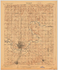
Other maps of this area

1896 · Seminole and Prague
USGS Topo · 1:125,000

1898 · Purcell
USGS Topo · 1:125,000

1905 · Chandler
USGS Topo · 1:62,500

1907 · Chandler
USGS Topo · 1:62,500

1907 · Maud
USGS Topo · 1:62,500

1908 · Maud
USGS Topo · 1:62,500

1909 · Shawnee
USGS Topo · 1:62,500

1909 · Luther
USGS Topo · 1:62,500

1910 · McComb
USGS Topo · 1:62,500

1929 · Stroud
USGS Topo · 1:62,500