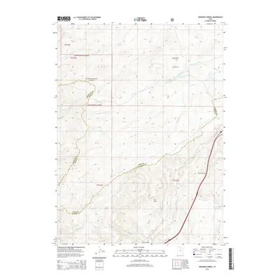
2014 Map of Shearing Corral
USGS Topo · Published 2014About this map
Cache National Forest dominates the high country of the Wasatch Range in this survey of northeastern Utah. The landscape is defined by its drainage systems, where Shearing Corral Creek and Suttons Creek carve through the high terrain. The map captures a high-elevation ranching and transport corridor, where local water management is evident in features like Shearing Corral Reservoir and Suttons Reservoir. The topography transitions from the high peaks of Lake Ridge in the northwest to the canyon floors of Lewis Canyon in the south.
Find a feature on this map
27 named features on this map. Tap any name to fly to it.
Don’t see what you’re looking for? This feature index may not catch every label — zoom into the map to look around manually.
Map Details
Editions of this 2014 Shearing Corral Map
This is the sole edition of this map. No revisions or reprints were ever made.
Other maps of this area

1954 · Ogden
USGS Topo · 1:250,000

1958 · Ogden
USGS Topo · 1:250,000

1960 · Ogden
USGS Topo · 1:250,000

1964 · Francis Canyon
USGS Topo · 1:24,000
1964 · Heiners Creek
USGS Topo · 1:24,000

1968 · Wahsatch
USGS Topo · 1:24,000
1968 · Porcupine Ridge
USGS Topo · 1:24,000

1968 · Shearing Corral
USGS Topo · 1:24,000

1968 · Mc Kay Hollow
USGS Topo · 1:24,000

1968 · Peck Canyon
USGS Topo · 1:24,000