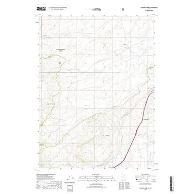
2020 Map of Shearing Corral
USGS Topo · Published 2020About this map
The Shearing Corral and its namesake Shearing Corral Reservoir anchor this high-altitude landscape where the borders of Summit, Morgan, and Rich counties meet. This area of the Cache National Forest is defined by a complex drainage system that feeds toward the southwest, with Suttons Creek and Shearing Corral Creek carving deep paths through the terrain. The presence of Heiners Springs and multiple reservoirs, including the Ball and Moore Reservoir, suggests the importance of water management for livestock and land use in this corner of Utah. A significant transportation corridor emerges in the southeast, where Echo Canyon and Tunnel Hollow provide passage for Interstate 80 and US Highway 189. The map details a transition from the high elevations of Lake Ridge and Red Rock down to these vital transit routes, illustrating the geography that has long dictated movement through these canyons.
Find a feature on this map
26 named features on this map. Tap any name to fly to it.
Don’t see what you’re looking for? This feature index may not catch every label — zoom into the map to look around manually.
Map Details
Editions of this 2020 Shearing Corral Map
This is the sole edition of this map. No revisions or reprints were ever made.
Other maps of this area

1954 · Ogden
USGS Topo · 1:250,000

1958 · Ogden
USGS Topo · 1:250,000

1960 · Ogden
USGS Topo · 1:250,000

1964 · Francis Canyon
USGS Topo · 1:24,000
1964 · Heiners Creek
USGS Topo · 1:24,000

1968 · Wahsatch
USGS Topo · 1:24,000
1968 · Porcupine Ridge
USGS Topo · 1:24,000

1968 · Shearing Corral
USGS Topo · 1:24,000

1968 · Mc Kay Hollow
USGS Topo · 1:24,000

1968 · Peck Canyon
USGS Topo · 1:24,000