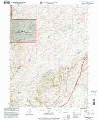
1998 Map of Shearing Corral
USGS Topo · Published 2001About this map
Cache National Forest encompasses much of this high-elevation landscape where the borders of Rich, Morgan, and Summit Counties converge. This late 20th-century survey illustrates a terrain defined by seasonal water management and pastoral infrastructure, notably the Shearing Corral and a series of high-country reservoirs including Shearing Reservoir and Suttons Reservoir. The network of Pipelines and a Pumping Station underscore the industrial efforts to manage water resources across Lake Ridge and down through Echo Canyon. Genealogists and historians will find interest in family-named landmarks like Heiners Spring and Lewis Canyon, as well as the specialized geography of Tristram Creek and Ball and Moore Reservoir. The map provides a clear look at the ranching legacy of the region, from Shearing to the geological prominence of Red Rock.
Find a feature on this map
25 named features on this map. Tap any name to fly to it.
Don’t see what you’re looking for? This feature index may not catch every label — zoom into the map to look around manually.
Map Details
Editions of this 1998 Shearing Corral Map
This is the sole edition of this map. No revisions or reprints were ever made.
Other maps of this area

1954 · Ogden
USGS Topo · 1:250,000

1958 · Ogden
USGS Topo · 1:250,000

1960 · Ogden
USGS Topo · 1:250,000

1964 · Francis Canyon
USGS Topo · 1:24,000
1964 · Heiners Creek
USGS Topo · 1:24,000

1968 · Wahsatch
USGS Topo · 1:24,000
1968 · Porcupine Ridge
USGS Topo · 1:24,000

1968 · Shearing Corral
USGS Topo · 1:24,000

1968 · Mc Kay Hollow
USGS Topo · 1:24,000

1968 · Peck Canyon
USGS Topo · 1:24,000