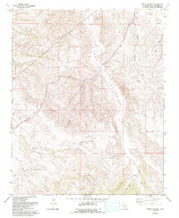
1961 Map of Shedd Canyon
USGS Topo · Published 1993About this map
Shedd Canyon and the surrounding high country of San Luis Obispo County are defined by a complex network of seasonal drainages and early rural infrastructure. This 1961 survey, updated through the early 1990s, reveals a landscape of working cattle and agricultural land where terrain dictates movement. To the northeast, the Shandon Valley opens up near Truesdale Road, while the interior is carved by Indian Creek, Upton Canyon, and Wood Canyon. Evidence of mid-century ranching and resource management is visible through numerous Well sites and isolated structures like Storage Bins. The map also traces a significant pipeline corridor cutting through the hills, illustrating how industrial utility lines were integrated into this remote part of the Huerhuero region. This record captures the transition of California's interior rangelands as modern infrastructure began to overlay traditional ranching boundaries.
Find a feature on this map
21 named features on this map. Tap any name to fly to it.
Don’t see what you’re looking for? This feature index may not catch every label — zoom into the map to look around manually.
Map Details
Editions of this 1961 Shedd Canyon Map
2 editions found
Other maps of this area

1897 · San Luis Obispo
USGS Topo · 1:62,500

1900 · San Luis
USGS Topo · 1:125,000

1914 · Cholame
USGS Topo · 1:125,000

1915 · Cholame
USGS Topo · 1:125,000

1917 · Cholame
USGS Topo · 1:125,000

1919 · Paso Robles
USGS Topo · 1:62,500

1922 · Pozo
USGS Topo · 1:62,500

1942 · San Luis Obispo
USGS Topo · 1:62,500

1943 · Shandon
USGS Topo · 1:31,680

1943 · Paso Robles
USGS Topo · 1:62,500