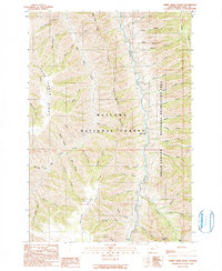
1990 Map of Sheep Creek Divide
USGS Topo · Published 1990About this map
The Imnaha River carves through a deeply dissected landscape of high ridges and narrow creek basins within the Wallowa National Forest. This high-country region is structured by massive geologic spines, including the central Sheep Creek Divide and the prominent Dead Horse Ridge. Human presence in this isolated terrain is sparse, centered on vital outposts like the College Creek Ranger Station and the Imnaha Grange.
Find a feature on this map
55 named features on this map. Tap any name to fly to it.
Don’t see what you’re looking for? This feature index may not catch every label — zoom into the map to look around manually.
Map Details
Editions of this 1990 Sheep Creek Divide Map
This is the sole edition of this map. No revisions or reprints were ever made.
Other maps of this area

1922 · He Devil
USGS Topo · 1:48,000

1954 · Imnaha
USGS Topo · 1:62,500

1954 · Kernan Point
USGS Topo · 1:62,500

1954 · Harl Butte
USGS Topo · 1:62,500

1955 · Grangeville
USGS Topo · 1:250,000

1957 · He Devil
USGS Topo · 1:62,500

1959 · Grangeville
USGS Topo · 1:250,000

1980 · Grangeville
USGS Topo · 1:100,000

1987 · Riggins
USGS Topo · 1:100,000

1990 · Imnaha
USGS Topo · 1:24,000