
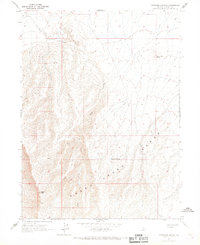
1965 Map of Sheep Creek Range SW
USGS Topo · Published 1967About this map
The Sheep Creek Range dominates this mid-1960s survey of Lander County, Nevada, where steep topography transitions into the broad expanse of Boulder Valley. Drainage patterns are clearly defined by the paths of Rock Creek and Mud Creek, which flow through the arid landscape. The map reveals the practical necessities of life in the high desert, documenting isolated water sources such as a Well located along an unnamed road in the valley floor. High-elevation features like the Mesa contrast with the level terrain of the basin, illustrating the stark relief typical of the central Nevada Great Basin region. This topographic record was compiled by the Geological Survey using aerial photographs from 1963 and subsequent field checks to ensure accuracy of the remote terrain.
Find a feature on this map
8 named features on this map. Tap any name to fly to it.
Don’t see what you’re looking for? This feature index may not catch every label — zoom into the map to look around manually.
Map Details
Editions of this 1965 Sheep Creek Range SW Map
This is the sole edition of this map. No revisions or reprints were ever made.
Other maps of this area

1955 · Winnemucca
USGS Topo · 1:250,000

1957 · Dunphy
USGS Topo · 1:62,500

1957 · Battle Mountain
USGS Topo · 1:62,500

1958 · Winnemucca
USGS Topo · 1:250,000

1962 · Winnemucca
USGS Topo · 1:250,000

1965 · Izzenhood Gap
USGS Topo · 1:24,000

1965 · Sheep Creek Range NE
USGS Topo · 1:24,000

1965 · Sheep Creek Range SE
USGS Topo · 1:24,000

1965 · Sheep Creek Range NW
USGS Topo · 1:24,000
1965 · Izzenhood Spring
USGS Topo · 1:24,000