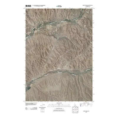
2010 Map of Sheep Ridge
USGS Topo · Published 2010About this map
Little Willow Creek and Big Willow Creek define the drainage patterns of this high-desert landscape in southwestern Idaho. The 2010 survey reveals an intricate network of irrigation infrastructure essential for local ranching and agriculture, including the McIntyre Canal, Nelson Canal, and Bolton Canal. These water systems wrap around the prominent Sheep Ridge and navigate the numerous gulches that carve through the terrain, such as Stone Quarry Gulch and Alley Gulch. This period shows a largely undeveloped rangeland where name-bearing landmarks like Bradford Spring and Sheep Spring served as vital water sources. The road network is primarily composed of unpaved tracks like Little Willow Rd and Stone Quarry Rd, reflecting the rural character and land use of the area near the turn of the 21st century.
Find a feature on this map
26 named features on this map. Tap any name to fly to it.
Don’t see what you’re looking for? This feature index may not catch every label — zoom into the map to look around manually.
Map Details
Editions of this 2010 Sheep Ridge Map
This is the sole edition of this map. No revisions or reprints were ever made.
Other maps of this area

1897 · Weiser
USGS Topo · 1:125,000

1898 · Nampa
USGS Topo · 1:125,000

1952 · Weiser Cove
USGS Topo · 1:24,000

1952 · Birding Island
USGS Topo · 1:24,000

1955 · Baker
USGS Topo · 1:250,000

1955 · Boise
USGS Topo · 1:250,000

1958 · Boise
USGS Topo · 1:250,000

1959 · Baker
USGS Topo · 1:250,000

1962 · Boise
USGS Topo · 1:250,000
1965 · New Plymouth
USGS Topo · 1:24,000