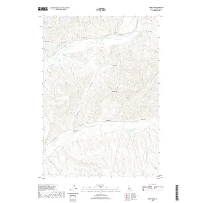
2020 Map of Sheep Ridge
USGS Topo · Published 2020About this map
Sheep Ridge dominates the central landscape of this section of Payette County, where high ground and deeply cut drainage channels define the rural terrain. The area's agricultural history is written in its water management, evidenced by the intricate system of gravity-fed waterways including the Nelson Canal, Bolton Canal, and Patton Canal. These irrigation structures follow the contours of the land above Little Willow Cr, supporting a ranching and farming economy dependent on seasonal runoff. Numerous named gulches like Clair Rose Gulch and Stone Quarry Gulch suggest a history of local resource extraction and family-held land claims. Local travel follows the winding paths of Big Willow Rd and Little Willow Rd, which trace the low-lying creek beds and provide access to the various canyons and springs, such as Sheep Spring, that dot the higher elevations.
Find a feature on this map
29 named features on this map. Tap any name to fly to it.
Don’t see what you’re looking for? This feature index may not catch every label — zoom into the map to look around manually.
Map Details
Editions of this 2020 Sheep Ridge Map
This is the sole edition of this map. No revisions or reprints were ever made.
Other maps of this area

1897 · Weiser
USGS Topo · 1:125,000

1898 · Nampa
USGS Topo · 1:125,000

1952 · Weiser Cove
USGS Topo · 1:24,000

1952 · Birding Island
USGS Topo · 1:24,000

1955 · Baker
USGS Topo · 1:250,000

1955 · Boise
USGS Topo · 1:250,000

1958 · Boise
USGS Topo · 1:250,000

1959 · Baker
USGS Topo · 1:250,000

1962 · Boise
USGS Topo · 1:250,000
1965 · New Plymouth
USGS Topo · 1:24,000