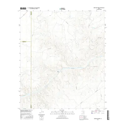
2016 Map of Sheep Run Creek
USGS Topo · Published 2016About this map
The Llano River cuts a wide path through this portion of the Texas Hill Country, defining the landscape of Kimble, Mason, and Menard counties. This 2016 survey highlights the intricate drainage network feeding the river, including the namesake Sheep Run Creek and the notable Cedar Hollow. The terrain is characterized by a high density of named water features such as Little Saline Cr and Big Bluff Cr, which have historically dictated the placement of rural access roads like Spring Hollow Rd and Ranch Rd 1871. A convergence of three county lines—Kimble, Mason, and Menard—creates a unique jurisdictional intersection near Tri Co Rd, illustrating how early land surveys used these natural watersheds to establish political boundaries.
Find a feature on this map
24 named features on this map. Tap any name to fly to it.
Don’t see what you’re looking for? This feature index may not catch every label — zoom into the map to look around manually.
Map Details
Editions of this 2016 Sheep Run Creek Map
This is the sole edition of this map. No revisions or reprints were ever made.
Other maps of this area

1887 · Mason
USGS Topo · 1:125,000

1894 · Mason
USGS Topo · 1:125,000

1954 · Llano
USGS Topo · 1:250,000

1955 · Llano
USGS Topo · 1:250,000

1956 · Llano
USGS Topo · 1:250,000
1967 · Monument Mountain SE
USGS Topo · 1:24,000

1968 · Monument Mountain
USGS Topo · 1:24,000
1968 · Turtle Creek
USGS Topo · 1:24,000

1968 · Sheep Run Creek
USGS Topo · 1:24,000

1968 · London
USGS Topo · 1:24,000