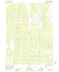
1983 Map of Sheepshead
USGS Topo · Published 1983About this map
Lassen National Forest terrain dominates this 1983 survey, revealing a landscape defined by isolated peaks and vital water management. The high-altitude geography is anchored by landmarks like Fort Mountain, Gooch Mtn, and Harvey Mtn, while the network of man-made and natural water sources reflects the region's ranching and resource history. Significant water features include Swanberger Reservoir, Heath Dam Reservoir, and the Grasshopper Valley Ditch, alongside numerous springs such as Board Cabin Spring and Cow Tail Spring. Local history is marked by the Gooch Camp (Site) and Indian Well, indicating earlier points of habitation and work. Industrial activity is noted at the Cinder Pit near the eastern boundary, while the Sheepshead Road provides the primary transit link through the Cleghorn Valley.
Find a feature on this map
34 named features on this map. Tap any name to fly to it.
Don’t see what you’re looking for? This feature index may not catch every label — zoom into the map to look around manually.
Map Details
Editions of this 1983 Sheepshead Map
2 editions found
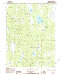
Other maps of this area

1886 · Honey Lake
USGS Topo · 1:250,000

1891 · Honey Lake
USGS Topo · 1:250,000

1893 · Honey Lake
USGS Topo · 1:250,000

1954 · Grasshopper Valley
USGS Topo · 1:62,500

1954 · Fredonyer Peak
USGS Topo · 1:62,500

1955 · Westwood
USGS Topo · 1:250,000

1956 · Hayden Hill
USGS Topo · 1:62,500

1956 · Antelope Mtn
USGS Topo · 1:62,500

1958 · Westwood
USGS Topo · 1:250,000

1959 · Westwood
USGS Topo · 1:250,000