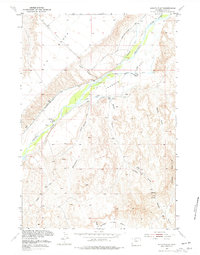
1951 Map of Sheets Flat
USGS Topo · Published 1977About this map
The Greybull River carves a fertile valley floor through this high-plains landscape, where mid-century irrigation efforts are documented in the network of the Rankin Ditch, Keystone Ditch, and Jimmerfield Ditch. While the uplands are dominated by the broad Y U Bench and Tatman Mountain, the valley bottom supports the Y U Ranch and the local Sheets Flat School.
Find a feature on this map
24 named features on this map. Tap any name to fly to it.
Don’t see what you’re looking for? This feature index may not catch every label — zoom into the map to look around manually.
Map Details
Editions of this 1951 Sheets Flat Map
2 editions found
Other maps of this area

1911 · Meeteetse
USGS Topo · 1:62,500

1911 · Oregon Basin
USGS Topo · 1:62,500

1913 · Oregon Basin
USGS Topo · 1:62,500

1913 · Meeteetse
USGS Topo · 1:62,500

1951 · Y U Bench NW
USGS Topo · 1:24,000

1951 · Y U Bench NE
USGS Topo · 1:24,000

1951 · Tatman Mountain
USGS Topo · 1:24,000

1951 · Sheets Flat
USGS Topo · 1:24,000

1951 · Wilson Spring
USGS Topo · 1:24,000

1951 · Dead Indian Hill
USGS Topo · 1:24,000