
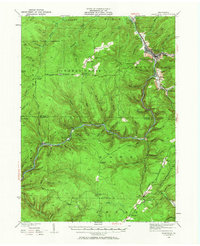
1935 Map of Sheffield
USGS Topo · Published 1935About this map
Tionesta Creek and its many winding tributaries dictate the rugged topography of this Forest County and Warren County region during the mid-1930s. The landscape is a network of deep runs and narrow valleys, where small settlements like Mayburg and Barnes are linked by the Pennsylvania Railroad and the Baltimore and Ohio. This era shows a transition between traditional resource extraction, evidenced by scattered Oil Wells and timber-era sidings like Dunham Siding, and new public works projects. The presence of CCC Camp No 2 and CCC Camp No 4 highlights the New Deal-era labor efforts within the State Game Preserve. Genealogists will find notable local landmarks such as Cherry Grove Cem and several rural schoolhouses, including Kingsley Sch and Austin Sch, which served these tight-knit valley communities before their consolidation.
Find a feature on this map
91 named features on this map. Tap any name to fly to it.
Don’t see what you’re looking for? This feature index may not catch every label — zoom into the map to look around manually.
Map Details
Editions of this 1935 Sheffield Map
2 editions found
Other maps of this area

1906 · Warren
USGS Topo · 1:62,500

1907 · Warren
USGS Topo · 1:62,500

1908 · Warren
USGS Topo · 1:62,500

1918 · Loleta
USGS Topo · 1:62,500

1922 · Tionesta
USGS Topo · 1:62,500

1924 · Tionesta
USGS Topo · 1:62,500

1926 · Youngsville
USGS Topo · 1:62,500

1927 · Tidioute
USGS Topo · 1:48,000

1929 · Youngsville
USGS Topo · 1:62,500

1930 · Tidioute
USGS Topo · 1:62,500
Featured Places
- Sheffield Township, PA
- Cherry Grove Township, PA
- Watson Township, PA
- Balltown, Howe Township
- Hermit Spring, PA