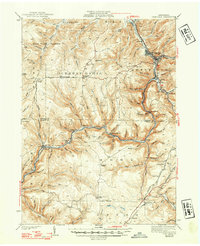
1941 Map of Sheffield
USGS Topo · Published 1948About this map
Tionesta Creek serves as the central artery for this 1930s landscape, illustrating the deep ties between the region's timber resources and its transport infrastructure. The presence of specialized industrial lines like the Wheeler and Dusenbury Lumber Co RR and the Hickory and Sheffield RR highlights the importance of the logging trade in the Warren and Forest County borderlands. Small, specialized settlements such as Henrys Mills and Truemans dot the creek valleys, while higher ground is home to rural landmarks like Hermit Spring and the Cherry Grove Cem. The map reveals a transition in land use, showing the State Game Preserve alongside the operations of the Baltimore and Ohio RR near Sheffield. This survey records a period when local life was organized around the narrow valleys and the specific demands of the extraction economy.
Find a feature on this map
92 named features on this map. Tap any name to fly to it.
Don’t see what you’re looking for? This feature index may not catch every label — zoom into the map to look around manually.
Map Details
Editions of this 1941 Sheffield Map
2 editions found

Other maps of this area

1906 · Warren
USGS Topo · 1:62,500

1907 · Warren
USGS Topo · 1:62,500

1908 · Warren
USGS Topo · 1:62,500

1918 · Loleta
USGS Topo · 1:62,500

1922 · Tionesta
USGS Topo · 1:62,500

1924 · Tionesta
USGS Topo · 1:62,500

1926 · Youngsville
USGS Topo · 1:62,500

1927 · Tidioute
USGS Topo · 1:48,000

1929 · Youngsville
USGS Topo · 1:62,500

1930 · Tidioute
USGS Topo · 1:62,500
Featured Places
- Sheffield Township, PA
- Cherry Grove Township, PA
- Watson Township, PA
- Balltown, Howe Township
- Hermit Spring, PA