
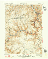
1941 Map of Sheffield
USGS Topo · Published 1941About this map
Tionesta Creek winds through this 1941 landscape, which is defined by the deep intersections of narrow runs and the timber-and-oil-driven economy of the era. The presence of the Tionesta Valley RR (ABANDONED) alongside active Baltimore and Ohio tracks illustrates a shifting transportation network, where older logging lines had already begun to fade from the terrain. Small hamlets and crossroads like Henrys Mills, Saybrook, and Balltown serve as focal points for local history, many of which are supported by rural institutions such as the Cherry Grove Sch and Austin Sch.
Find a feature on this map
86 named features on this map. Tap any name to fly to it.
Don’t see what you’re looking for? This feature index may not catch every label — zoom into the map to look around manually.
Map Details
Editions of this 1941 Sheffield Map
2 editions found
Other maps of this area

1906 · Warren
USGS Topo · 1:62,500

1907 · Warren
USGS Topo · 1:62,500

1908 · Warren
USGS Topo · 1:62,500

1918 · Loleta
USGS Topo · 1:62,500

1922 · Tionesta
USGS Topo · 1:62,500

1924 · Tionesta
USGS Topo · 1:62,500

1926 · Youngsville
USGS Topo · 1:62,500

1927 · Tidioute
USGS Topo · 1:48,000

1929 · Youngsville
USGS Topo · 1:62,500

1930 · Tidioute
USGS Topo · 1:62,500
Featured Places
- Sheffield Township, PA
- Cherry Grove Township, PA
- Watson Township, PA
- Balltown, Howe Township
- Hermit Spring, PA