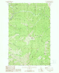
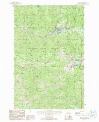
1988 Map of Shefoot Mountain
USGS Topo · Published 1988About this map
St Joe National Forest dominates this topographic landscape in Shoshone County, defined by the winding course of the North Fork Joe River and several prominent summits. The map provides a detailed view of the region's industrial and recreational history through the inclusion of numerous Pack Trails and the defunct Old RR Grade that traverses the northern ridges. Early 20th-century mining activity is evidenced by an Adit and various Prospects located near Kelly Pinnacle. The high-elevation terrain is marked by distinctive local landmarks such as Shefoot Mountain, Triangle Peak, and Turner Peak. Many features bear unique local names including Big Dick Point and Long Liz Point, which overlook a network of drainages like Brushy Creek and Bluebird Creek. The presence of the railroad grade and extensive trail system indicates a landscape historically tied to logging, mining, and forest management.
Find a feature on this map
38 named features on this map. Tap any name to fly to it.
Don’t see what you’re looking for? This feature index may not catch every label — zoom into the map to look around manually.
Map Details
Editions of this 1988 Shefoot Mountain Map
This is the sole edition of this map. No revisions or reprints were ever made.
Other maps of this area

1914 · Avery
USGS Topo · 1:125,000

1917 · Avery
USGS Topo · 1:125,000

1956 · Saltese
USGS Topo · 1:62,500

1956 · Wallace
USGS Topo · 1:250,000

1957 · Wallace
USGS Topo · 1:62,500

1960 · Wallace
USGS Topo · 1:250,000
1969 · Thor Mountain
USGS Topo · 1:24,000
1969 · Three Sisters
USGS Topo · 1:24,000
1969 · Fishhook Creek
USGS Topo · 1:24,000
1988 · Mullan
USGS Topo · 1:24,000