
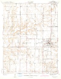
1942 Map of Shelburn
USGS Topo · Published 1942About this map
The coal-rich landscape of Curry and Hamilton townships is centered on the mining and rail hub of Shelburn. In the early 1940s, the Chicago and Eastern Illinois railroad provided the primary artery for industrial output, serving local operations like the Linda Lou Mine. The map reveals a dense network of small settlements and neighborhood clusters including Curryville, Miner City, and Standard, reflecting a period when worker housing was closely tied to the nearby collieries.
Find a feature on this map
26 named features on this map. Tap any name to fly to it.
Don’t see what you’re looking for? This feature index may not catch every label — zoom into the map to look around manually.
Map Details
Editions of this 1942 Shelburn Map
2 editions found
Other maps of this area

1932 · Marshall
USGS Topo · 1:62,500

1937 · Marshall
USGS Topo · 1:62,500

1940 · Lewis
USGS Topo · 1:24,000

1940 · Pimento
USGS Topo · 1:24,000

1942 · Fairbanks
USGS Topo · 1:24,000

1942 · Hutton
USGS Topo · 1:24,000

1943 · Merom
USGS Topo · 1:24,000

1943 · Hymera
USGS Topo · 1:24,000

1943 · Sullivan
USGS Topo · 1:24,000

1943 · Dugger
USGS Topo · 1:24,000