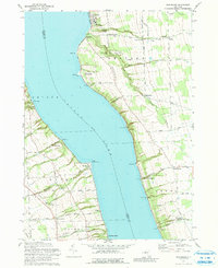
1971 Map of Sheldrake
USGS Topo · Published 1991About this map
The eastern and western shores of Cayuga Lake meet on this 1971 survey, showing a landscape defined by steep lakeside gullies and upland agricultural plateaus. On the eastern shore, the village of Aurora is a primary anchor, notable for the lakefront campus of Wells College. This side of the lake follows a series of sharp ravines such as Beard Gully and Carter Gully, with rural crossroads like Jump Corners and Chapel Corners distributed across the high ground of Ledyard and Genoa.
Find a feature on this map
66 named features on this map. Tap any name to fly to it.
Don’t see what you’re looking for? This feature index may not catch every label — zoom into the map to look around manually.
Map Details
Editions of this 1971 Sheldrake Map
2 editions found
Other maps of this area

1899 · Auburn
USGS Topo · 1:62,500

1902 · Geneva
USGS Topo · 1:62,500

1902 · Genoa
USGS Topo · 1:62,500

1902 · Ovid
USGS Topo · 1:62,500

1902 · Auburn
USGS Topo · 1:62,500

1942 · Ovid
USGS Topo · 1:31,680

1942 · Ludlowville
USGS Topo · 1:24,000

1942 · Lodi
USGS Topo · 1:24,000

1942 · Sheldrake
USGS Topo · 1:24,000

1942 · Genoa
USGS Topo · 1:24,000