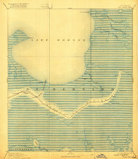
1893 Map of Shell Beach
USGS Topo · Published 1921About this map
St Bernard Parish and the marshes of the Mississippi River delta appear here during the late nineteenth century, dominated by the sweeping waters of Lake Borgne. The Louisiana Southern railroad serves as the primary artery for the region, terminating at Shell Beach where the shoreline meets the open water. This rail connection highlights the area's importance as a coastal hub before the shifting geography of the twentieth century altered the landscape. Inland, settlements like Florissant, Yscloskey, and Hopedale are established along the winding course of Bayou La Loutre, following the natural high ground of the bayou levees. Cultural landmarks are noted by the presence of an Artificial Mound 25 Ft. and various other Mounds, indicating a long history of human habitation within this complex network of lagoons and waterways like Sol's Lagoon and Lake Jean Louis Robin (Dime).
Find a feature on this map
24 named features on this map. Tap any name to fly to it.
Don’t see what you’re looking for? This feature index may not catch every label — zoom into the map to look around manually.
Map Details
Editions of this 1893 Shell Beach Map
3 editions found
Other maps of this area

1891 · Pointe a La Hache
USGS Topo · 1:62,500

1892 · Chef Menteur
USGS Topo · 1:62,500

1892 · St. Bernard
USGS Topo · 1:62,500

1892 · Pointe a La Hache
USGS Topo · 1:62,500

1893 · Rigolets
USGS Topo · 1:62,500

1893 · La Fortuna
USGS Topo · 1:62,500

1893 · Shell Beach
USGS Topo · 1:62,500

1893 · Toulme
USGS Topo · 1:62,500

1893 · Dime
USGS Topo · 1:62,500

1895 · Bodreau
USGS Topo · 1:62,500