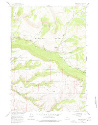
1960 Map of Shell Falls
USGS Topo · Published 1978About this map
Bighorn National Forest dominates this landscape, where the dramatic descent of Shell Creek creates the centerpiece of Shell Canyon. This 1960 field-checked survey documents a transition in land use, showing established government infrastructure like the Shell Creek Ranger Sta alongside the growing recreational footprints of the Granite Creek Campground, Cabin Creek Campground, and Ranger Creek Campground. Public access is anchored by the Shell Falls Observation Point, situated where the water carves through steep limestone and granite walls. Higher elevations reveal a network of drainages including Brindle Creek, Grouse Creek, and the Dry Fork, which define the rugged geography near Copemans Tomb and Snowshoe Mountain. The map also captures the path of the primary road through the canyon, providing a precise record of how these remote forest lands were navigated and managed during the mid-twentieth century.
Find a feature on this map
35 named features on this map. Tap any name to fly to it.
Don’t see what you’re looking for? This feature index may not catch every label — zoom into the map to look around manually.
Map Details
Editions of this 1960 Shell Falls Map
2 editions found
Other maps of this area

1895 · Dayton
USGS Topo · 1:125,000

1898 · Bald Mountain
USGS Topo · 1:125,000

1899 · Cloud peak
USGS Topo · 1:125,000

1901 · Cloud Peak
USGS Topo · 1:125,000

1901 · Dayton
USGS Topo · 1:125,000

1901 · Bald Mountain
USGS Topo · 1:125,000

1955 · Sheridan
USGS Topo · 1:250,000

1958 · Sheridan
USGS Topo · 1:250,000

1960 · Shell Falls
USGS Topo · 1:24,000

1960 · White Sulphur Spring
USGS Topo · 1:24,000