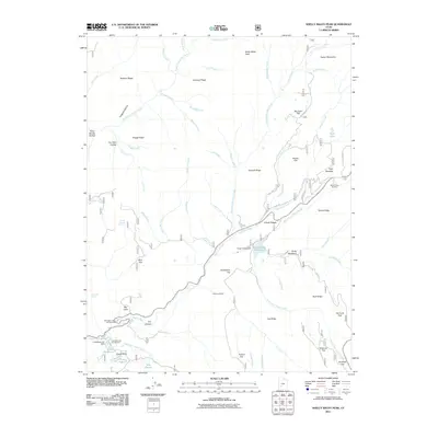
2011 Map of Shelly Baldy Peak
USGS Topo · Published 2011About this map
The Tushar Mountains dominate this high-altitude landscape, centered on the prominent Shelly Baldy Peak. This 2011 survey reveals a region defined by recreational infrastructure and seasonal mountain pastures, including the Mount Holly Ski Area and the Mahogany Cove Campground. Water management is central to the area's geography, evidenced by the Three Creeks Reservoir and Little Reservoir Dam, which regulate the flow of numerous alpine streams like Merchant Creek and the South Fork Beaver River.
Find a feature on this map
74 named features on this map. Tap any name to fly to it.
Don’t see what you’re looking for? This feature index may not catch every label — zoom into the map to look around manually.
Map Details
Editions of this 2011 Shelly Baldy Peak Map
This is the sole edition of this map. No revisions or reprints were ever made.
Other maps of this area

1885 · Beaver
USGS Topo · 1:250,000

1937 · Delano Peak
USGS Topo · 1:48,000

1943 · Delano Peak
USGS Topo · 1:62,500

1953 · Richfield
USGS Topo · 1:250,000

1954 · Beaver SE
USGS Topo · 1:24,000

1954 · Beaver NE
USGS Topo · 1:24,000

1958 · Richfield
USGS Topo · 1:250,000

1958 · Beaver
USGS Topo · 1:62,500

1966 · Circleville
USGS Topo · 1:24,000
1971 · Kane Canyon
USGS Topo · 1:24,000