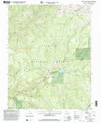
2001 Map of Shelly Baldy Peak
USGS Topo · Published 2003About this map
Fishlake National Forest dominates this high-altitude landscape on the boundary of Beaver and Piute counties. The terrain is defined by extreme relief, descending from peaks like Shelly Baldy Peak into deep drainages such as Baker Canyon. This 2001 revision illustrates the specialized recreational and industrial infrastructure required to inhabit these heights, featuring the Mount Holly Ski Area and the Mahogany Cove Campground. Water management is a primary theme, with a complex network of creeks including Merchant Creek and Three Creeks feeding into the Three Creeks Reservoir. The southern portion of the map shows a concentrated area of activity where the Beaver River is supported by an aqueduct and a Powerplant, indicating the vital role of the river in local energy and irrigation. Pockets of human history are scattered throughout the flats and basins, from the intriguing label of Robbers Roost to the remote outposts of Cys Cache and Harmony Park.
Find a feature on this map
74 named features on this map. Tap any name to fly to it.
Don’t see what you’re looking for? This feature index may not catch every label — zoom into the map to look around manually.
Map Details
Editions of this 2001 Shelly Baldy Peak Map
This is the sole edition of this map. No revisions or reprints were ever made.
Other maps of this area

1885 · Beaver
USGS Topo · 1:250,000

1937 · Delano Peak
USGS Topo · 1:48,000

1943 · Delano Peak
USGS Topo · 1:62,500

1953 · Richfield
USGS Topo · 1:250,000

1954 · Beaver SE
USGS Topo · 1:24,000

1954 · Beaver NE
USGS Topo · 1:24,000

1958 · Richfield
USGS Topo · 1:250,000

1958 · Beaver
USGS Topo · 1:62,500

1966 · Circleville
USGS Topo · 1:24,000
1971 · Kane Canyon
USGS Topo · 1:24,000