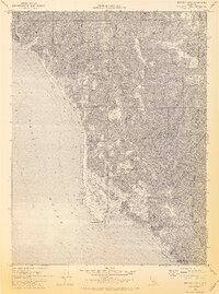
1969 Map of Shelter Cove
USGS Topo · Published 1974About this map
Shelter Cove and the prominent Point Delgada anchor this coastal landscape where the King Range meets the Pacific Ocean. This 1969 survey captures the development at the cove, showing a network of streets near the Landing Strip, a Filtration Plant, and Sewage Disposal infrastructure alongside the natural terrain of the Lost Coast. The map documents several recreational outposts, including Honeydew Campground, Tolkan Campground, Nadelos Campground, and Wailaki Campground, illustrating the area's transition into a destination for wilderness access. Topography is defined by high ridges like Horse Mountain Ridge and Jewett Ridge, which rise sharply from the shore. The drainage system is complex, with numerous coastal streams such as Telegraph Creek, Dead Mans Gulch, and Horse Mountain Creek carving through the steep slopes. Faint evidence of historical industry remains visible through marked Mines located in the eastern uplands near Chemise Mountain.
Find a feature on this map
43 named features on this map. Tap any name to fly to it.
Don’t see what you’re looking for? This feature index may not catch every label — zoom into the map to look around manually.
Map Details
Editions of this 1969 Shelter Cove Map
3 editions found
Other maps of this area

1920 · Pt. Delagda
USGS Topo · 1:62,500

1921 · Briceland
USGS Topo · 1:62,500

1949 · Eureka
USGS Topo · 1:250,000

1949 · Point Delgada
USGS Topo · 1:62,500

1949 · Garberville
USGS Topo · 1:62,500

1950 · Piercy
USGS Topo · 1:62,500

1951 · Garberville
USGS Topo · 1:62,500

1951 · Point Delgada
USGS Topo · 1:62,500

1957 · Ukiah
USGS Topo · 1:250,000

1958 · Redding
USGS Topo · 1:250,000