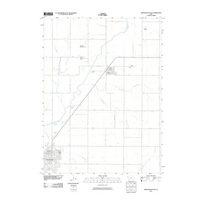
2010 Map of Shenandoah East
USGS Topo · Published 2010About this map
Shenandoah and Essex anchor this agricultural landscape in Page County, where the grid of rural roads is interrupted by the meandering course of the East Nishnabotna River. The settlement pattern reflects a stable farming community with essential services clustered in the towns, including the Shenandoah Post Office and the Essex Post Office. Outside the residential centers, the land is divided by a series of named watercourses such as Fourmile Creek and Rocky Branch, which carve through the Iowa plains. For genealogists, the map is particularly valuable for its documentation of local burial sites, including the Saint John Evangelical Lutheran Cemetery, Hadden Cemetery, and Rose Hill Cemetery. The layout of the road network, with arteries like D Ave and 150 St, shows the connectivity between these small agrarian hubs and the surrounding countryside during the early 21st century.
Find a feature on this map
33 named features on this map. Tap any name to fly to it.
Don’t see what you’re looking for? This feature index may not catch every label — zoom into the map to look around manually.
Map Details
Editions of this 2010 Shenandoah East Map
This is the sole edition of this map. No revisions or reprints were ever made.
Other maps of this area

1939 · Farragut
USGS Topo · 1:62,500

1940 · Farragut
USGS Topo · 1:62,500

1940 · Coin
USGS Topo · 1:62,500

1943 · Coin
USGS Topo · 1:62,500

1955 · Nebraska City
USGS Topo · 1:250,000

1957 · Nebraska City
USGS Topo · 1:250,000

1958 · Nebraska City
USGS Topo · 1:250,000

1978 · Shenandoah East
USGS Topo · 1:24,000

1978 · Stanton SW
USGS Topo · 1:24,000
1978 · Shenandoah West
USGS Topo · 1:24,000