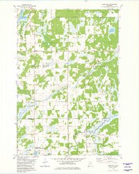
1981 Map of Shephard
USGS Topo · Published 1982About this map
The Nokasippi River and Platte River systems dominate this central Minnesota landscape, defining the rural character of the region in the early 1980s. A intricate network of smaller waterways including Daggett Brook, Coon Creek, and Swamp Brook thread through the township divisions of Maple Grove, Daggett Brook, and Platte Lake. This survey captures the sparse settlement patterns typical of the area, centered around locations like Shephard and the local Townhall. Local history and genealogy are anchored by the Pine Tree Cem and numerous family-held parcels that border the extensive Wittker State Wildlife Management Area. The map reveals a reliance on natural resources and land management, with scattered Gravel Pits and a prominent industrial Pipeline cutting across the north. The boundary line between Crow Wing Co and Morrison Co marks the southern edge of this survey, where the river plains meet the managed wildlife lands.
Find a feature on this map
21 named features on this map. Tap any name to fly to it.
Don’t see what you’re looking for? This feature index may not catch every label — zoom into the map to look around manually.
Map Details
Editions of this 1981 Shephard Map
This is the sole edition of this map. No revisions or reprints were ever made.
Other maps of this area

1912 · Deerwood
USGS Topo · 1:62,500

1914 · Deerwood
USGS Topo · 1:62,500

1915 · Brainerd
USGS Topo · 1:62,500

1918 · Brainerd
USGS Topo · 1:62,500

1948 · Lastrup
USGS Topo · 1:62,500

1950 · Lastrup
USGS Topo · 1:62,500

1953 · Duluth
USGS Topo · 1:250,000

1953 · Brainerd
USGS Topo · 1:250,000

1957 · Brainerd
USGS Topo · 1:250,000

1958 · Brainerd
USGS Topo · 1:250,000