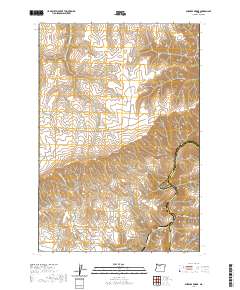
2020 Map of Sherars Bridge
USGS Topo · Published 2020About this map
Tygh Ridge dominates the northern landscape of this Wasco County quadrangle, where the high basalt plateaus drop sharply toward the Deschutes River. This 2020 survey documents a transition from the agricultural uplands down to the river corridor, a path historically marked by the crossing at Sherars Bridge near the churning waters of Sherars Falls. The intricate network of market roads, including Tygh Ridge Mkt Rd and Old Tygh Mkt Rd, provides a modern look at the routes connecting high-country ranching land to the settlements of Oak Canyon and Buck Hollow. For those tracing local history, the Warner Cem sits on a plateau overlooking the drainage of Dry Cr. The map captures the complex topography of the canyonlands, including deep incisions like Chicken Spring Canyon and Kerr Canyon that define the eastern border with Sherman County.
Find a feature on this map
26 named features on this map. Tap any name to fly to it.
Don’t see what you’re looking for? This feature index may not catch every label — zoom into the map to look around manually.
Map Details
Editions of this 2020 Sherars Bridge Map
This is the sole edition of this map. No revisions or reprints were ever made.
Other maps of this area

1930 · Dufur
USGS Topo · 1:125,000

1934 · Dufur
USGS Topo · 1:125,000

1953 · The Dalles
USGS Topo · 1:250,000

1956 · The Dalles
USGS Topo · 1:250,000

1957 · The Dalles
USGS Topo · 1:250,000

1962 · Sherars Bridge
USGS Topo · 1:24,000

1962 · Postage Stamp Butte
USGS Topo · 1:24,000

1962 · Summit Ridge
USGS Topo · 1:24,000

1962 · Dufur East
USGS Topo · 1:24,000

1962 · Sinamox
USGS Topo · 1:24,000