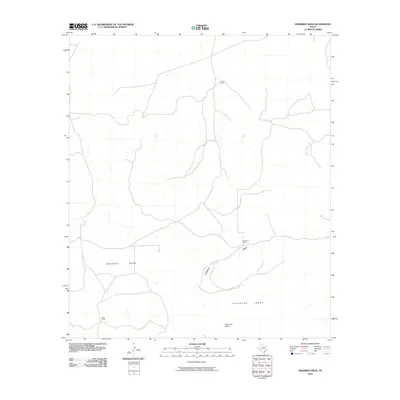
2010 Map of Sherbino Mesa
USGS Topo · Published 2010About this map
Sherbino Mesa and Mckenzie Mesa anchor this Pecos County landscape, reflecting the classic plateau-and-draw topography of West Texas. The map depicts a territory defined by large-scale ranching operations, where development is concentrated around family-named outposts like Hillin Ranch in the north and Harrelson Ranch near the center. These ranch sites are connected by a sparse network of improved and unimproved roads that navigate the local drainages, most notably Fourmile Draw. The spatial distribution of Ligon Ranch and other named homesteads illustrates the isolated nature of contemporary land use in this arid region. The lack of traditional town centers highlights a rural economy still deeply rooted in the stewardship of vast upland grazing territories and the vital, seasonal watercourses that carve through the mesa systems.
Find a feature on this map
7 named features on this map. Tap any name to fly to it.
Don’t see what you’re looking for? This feature index may not catch every label — zoom into the map to look around manually.
Map Details
Editions of this 2010 Sherbino Mesa Map
This is the sole edition of this map. No revisions or reprints were ever made.
Other maps of this area

1929 · Independence Draw Quadrangle
USGS Topo · 1:125,000

1954 · Fort Stockton
USGS Topo · 1:250,000

1958 · Fort Stockton
USGS Topo · 1:250,000

1969 · Bootleg Canyon
USGS Topo · 1:24,000

1969 · Skyscraper Peak
USGS Topo · 1:24,000

1969 · Hackberry Draw NW
USGS Topo · 1:24,000

1969 · Hackberry Draw NE
USGS Topo · 1:24,000
1969 · Hat-A Ranch
USGS Topo · 1:24,000

1969 · Indian Mesa
USGS Topo · 1:24,000

1969 · Bakersfield
USGS Topo · 1:24,000