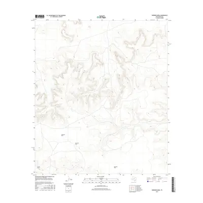
2016 Map of Sherbino Mesa
USGS Topo · Published 2016About this map
Sherbino Mesa and McKenzie Mesa dominate this West Texas landscape, where the plateau surfaces are cut by deep drainage systems. These elevated landforms, characteristic of Pecos County, rise sharply above the surrounding desert floor. The intricate contour patterns reveal the erosional forces that have shaped the region over millennia, creating a network of dry washes and seasonal watercourses. Fourmile Draw and Harral Draw provide the primary pathways for intermittent runoff, carving significant depressions through the arid terrain. While the map is largely defined by these natural features, the sparse network of local roads and connectors reflects the isolation and cattle-ranching heritage of this high-plains environment during the mid-2010s.
Find a feature on this map
4 named features on this map. Tap any name to fly to it.
Don’t see what you’re looking for? This feature index may not catch every label — zoom into the map to look around manually.
Map Details
Editions of this 2016 Sherbino Mesa Map
This is the sole edition of this map. No revisions or reprints were ever made.
Other maps of this area

1929 · Independence Draw Quadrangle
USGS Topo · 1:125,000

1954 · Fort Stockton
USGS Topo · 1:250,000

1958 · Fort Stockton
USGS Topo · 1:250,000

1969 · Bootleg Canyon
USGS Topo · 1:24,000

1969 · Skyscraper Peak
USGS Topo · 1:24,000

1969 · Hackberry Draw NW
USGS Topo · 1:24,000

1969 · Hackberry Draw NE
USGS Topo · 1:24,000
1969 · Hat-A Ranch
USGS Topo · 1:24,000

1969 · Indian Mesa
USGS Topo · 1:24,000

1969 · Bakersfield
USGS Topo · 1:24,000