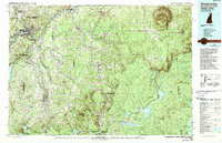
1986 Map of Sherbrooke
USGS Topo · Published 1989About this map
The international borderlands of northern New England and Quebec come together in this mid-1980s topographical study, anchored by the urban center of Sherbrooke and the confluence of the Saint-François Rivière and Rivière Magog. The landscape is dominated by the massive profile of Mont Megantic in the north and the high ridges of Hereford Mountain near the Vermont line. This map captures the upper reaches of the Connecticut River watershed, showing the sequence of the Third Connecticut Lake, Second Connecticut Lake, and First Connecticut Lake as they feed into Lake Francis within the township of Pittsburg. The drainage patterns of the Rivière Coaticook and Rivière Eaton illustrate the complex hydraulic network that supported regional industry and agriculture across the Canada-United States boundary. From the mill town of Coaticook to the protected forests of Dixville Notch State Park, the map documents a region where geography often supersedes political borders.
Find a feature on this map
104 named features on this map. Tap any name to fly to it.
Don’t see what you’re looking for? This feature index may not catch every label — zoom into the map to look around manually.
Map Details
Editions of this 1986 Sherbrooke Map
2 editions found
Other maps of this area

1919 · Lake Memphremagog
USGS Topo · 1:62,500

1920 · Derby
USGS Topo · 1:62,500

1923 · Lake Memphremagog
USGS Topo · 1:48,000

1924 · Island Pond
USGS Topo · 1:48,000

1925 · Indian Stream
USGS Topo · 1:48,000

1925 · Memphremagog
USGS Topo · 1:62,500

1926 · Island Pond
USGS Topo · 1:62,500

1926 · Indian Stream
USGS Topo · 1:62,500

1927 · Indian Stream
USGS Topo · 1:62,500

1927 · Moose Bog
USGS Topo · 1:48,000