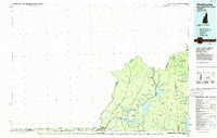
1986 Map of Sherbrooke
USGS Topo · Published 1986About this map
The northernmost reaches of the Connecticut River define this frontier landscape where New Hampshire, Maine, Vermont, and Quebec converge. The drainage system is anchored by the remarkable chain of Connecticut Lakes, from the high Fourth Connecticut Lake near the international boundary down to the expansive waters of Lake Francis. In this corner of Coos County, the settlement of Pittsburg serves as a hub for a region dominated by timber interests and remote townships like Parmachenee and Lynchtown.
Find a feature on this map
52 named features on this map. Tap any name to fly to it.
Don’t see what you’re looking for? This feature index may not catch every label — zoom into the map to look around manually.
Map Details
Editions of this 1986 Sherbrooke Map
2 editions found
Other maps of this area

1919 · Lake Memphremagog
USGS Topo · 1:62,500

1920 · Derby
USGS Topo · 1:62,500

1923 · Lake Memphremagog
USGS Topo · 1:48,000

1924 · Island Pond
USGS Topo · 1:48,000

1925 · Indian Stream
USGS Topo · 1:48,000

1925 · Memphremagog
USGS Topo · 1:62,500

1926 · Island Pond
USGS Topo · 1:62,500

1926 · Indian Stream
USGS Topo · 1:62,500

1927 · Indian Stream
USGS Topo · 1:62,500

1927 · Moose Bog
USGS Topo · 1:48,000