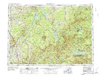
1976 Map of Sherbrooke
USGS Topo · Published 1976About this map
Lac Mégantic serves as a prominent geographic anchor in this cross-border region, where the mountainous terrain of Quebec meets the northern reaches of Maine. The map detail highlights the industrial and transport ties of the mid-20th century, particularly the Canadian Pacific and Grand Trunk railroads that carved routes through the Stoke Mountains and Megantic Mountain. The international boundary is clearly defined, punctuated by the U.S. Customs Station near Jackman, illustrating the regulated flow of goods and people between nations during this era.
Find a feature on this map
41 named features on this map. Tap any name to fly to it.
Don’t see what you’re looking for? This feature index may not catch every label — zoom into the map to look around manually.
Map Details
Editions of this 1976 Sherbrooke Map
2 editions found
Other maps of this area

1903 · Bingham
USGS Topo · 1:62,500

1904 · Anson
USGS Topo · 1:62,500

1905 · Bingham
USGS Topo · 1:62,500

1905 · The Forks
USGS Topo · 1:62,500

1907 · The Forks
USGS Topo · 1:62,500

1919 · Lake Memphremagog
USGS Topo · 1:62,500

1920 · Derby
USGS Topo · 1:62,500

1921 · Brassua Lake
USGS Topo · 1:62,500

1922 · Long Pond
USGS Topo · 1:62,500

1923 · Brassua Lake
USGS Topo · 1:62,500