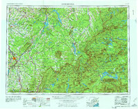
1976 Map of Sherbrooke
USGS Topo · Published 1976About this map
Thetford Mines and the industrial corridors of the Eastern Townships anchor the northwestern reaches of this international survey. The landscape is defined by the high elevations of the Boundary Mountains and Bigelow Mountain, forming the rugged watershed between the St. Lawrence and Atlantic drainage systems. Trans-border connections are visible through the complex rail networks of the Canadian Pacific and Quebec Central, which facilitated the movement of timber and mineral resources across the Canada-United States border during the mid-20th century.
Find a feature on this map
93 named features on this map. Tap any name to fly to it.
Don’t see what you’re looking for? This feature index may not catch every label — zoom into the map to look around manually.
Map Details
Editions of this 1976 Sherbrooke Map
2 editions found
Other maps of this area

1903 · Bingham
USGS Topo · 1:62,500

1904 · Anson
USGS Topo · 1:62,500

1905 · Bingham
USGS Topo · 1:62,500

1905 · The Forks
USGS Topo · 1:62,500

1907 · The Forks
USGS Topo · 1:62,500

1919 · Lake Memphremagog
USGS Topo · 1:62,500

1920 · Derby
USGS Topo · 1:62,500

1921 · Brassua Lake
USGS Topo · 1:62,500

1922 · Long Pond
USGS Topo · 1:62,500

1923 · Brassua Lake
USGS Topo · 1:62,500