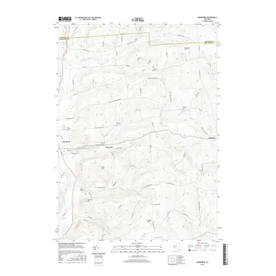
2016 Map of Sherburne
USGS Topo · Published 2016About this map
Harrisville and Columbus anchor this rural landscape where the Chenango River valley meets the rising topography of the Southern Tier. A legacy of early industry and community life is visible in road names like Casey Cheese Factory Rd and Furman Mill Rd, tracing the agricultural and milling history of the region. The area's complex hydrology is defined by the descent of Mad Brook toward Rexford Falls, while higher elevations are marked by distinctive peaks such as Sugarloaf Mtn and Hunts Mtn. Genealogists will find a wealth of burial sites across the township, including Saint Malachy Cem, Howard Cem, and the Tillotson Cem, which are scattered among family-named landmarks like Skinner Hill and Columbus Hill. This survey captures the enduring rural character of the area, where small settlements persist amidst a network of brooks and ridge-top roads.
Find a feature on this map
84 named features on this map. Tap any name to fly to it.
Don’t see what you’re looking for? This feature index may not catch every label — zoom into the map to look around manually.
Map Details
Editions of this 2016 Sherburne Map
This is the sole edition of this map. No revisions or reprints were ever made.
Other maps of this area

1902 · Morrisville
USGS Topo · 1:62,500

1903 · Norwich
USGS Topo · 1:62,500

1907 · Sangerfield
USGS Topo · 1:62,500

1910 · New Berlin
USGS Topo · 1:62,500

1912 · New Berlin
USGS Topo · 1:62,500

1943 · New Berlin North
USGS Topo · 1:24,000

1943 · New Berlin South
USGS Topo · 1:24,000

1943 · Hubbardsville
USGS Topo · 1:24,000

1943 · Sangerfield
USGS Topo · 1:62,500
1943 · Brookfield
USGS Topo · 1:24,000