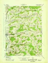
1945 Map of Sherburne
USGS Topo · Published 1945About this map
Sherburne and the Chenango River valley form the western focus of this mid-1940s survey, where the valley floor still shows the path of the Abandoned Chenango Canal. This transportation history is further etched into the landscape by the Sherburne Turnpike and the network of local ways like Granville Road and Knapp Road that connect high-elevation farmsteads. The terrain rises sharply from the river to peaks such as Hunts Mountain and Sugarloaf Mtn, separating the valley from the upland hamlets of Harrisville and Columbus.
Find a feature on this map
45 named features on this map. Tap any name to fly to it.
Don’t see what you’re looking for? This feature index may not catch every label — zoom into the map to look around manually.
Map Details
Editions of this 1945 Sherburne Map
This is the sole edition of this map. No revisions or reprints were ever made.
Other maps of this area

1902 · Morrisville
USGS Topo · 1:62,500

1903 · Norwich
USGS Topo · 1:62,500

1907 · Sangerfield
USGS Topo · 1:62,500

1910 · New Berlin
USGS Topo · 1:62,500

1912 · New Berlin
USGS Topo · 1:62,500

1943 · New Berlin North
USGS Topo · 1:24,000

1943 · New Berlin South
USGS Topo · 1:24,000

1943 · Hubbardsville
USGS Topo · 1:24,000

1943 · Sangerfield
USGS Topo · 1:62,500
1943 · Brookfield
USGS Topo · 1:24,000