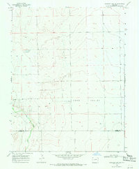
1968 Map of Sheridan Lake SW
USGS Topo · Published 1971About this map
Big Sandy Creek winds through the southwestern corner of this Colorado landscape, marking a distinct drainage pattern against the high plains of the Kiowa Co and Prowers Co border. This 1968 survey reveals a sparse, rural environment dominated by wide depressions like Coon Valley and occasional landmarks such as Lone. The terrain is defined by a series of low ridges and intermittent water sources, indicated by several scattered Well sites that supported local ranching or agricultural efforts during this period. The survey captures the exact township and range divisions of this borderland, where the straight-line political boundary between counties contrasts with the natural, erratic path of the creek bed. This map serves as a precise record of land use and water management in a region where every well and topographical feature is a critical marker of the local geography.
Find a feature on this map
6 named features on this map. Tap any name to fly to it.
Don’t see what you’re looking for? This feature index may not catch every label — zoom into the map to look around manually.
Map Details
Editions of this 1968 Sheridan Lake SW Map
This is the sole edition of this map. No revisions or reprints were ever made.
Other maps of this area

1890 · Granada
USGS Topo · 1:125,000

1892 · Lamar
USGS Topo · 1:125,000

1892 · Granada
USGS Topo · 1:125,000

1894 · Granada
USGS Topo · 1:125,000

1954 · Lamar
USGS Topo · 1:250,000

1955 · Granada NW
USGS Topo · 1:24,000

1955 · Granada NE
USGS Topo · 1:24,000

1955 · May Valley
USGS Topo · 1:24,000

1958 · Lamar
USGS Topo · 1:250,000

1968 · Sheridan Lake
USGS Topo · 1:24,000