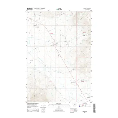
2014 Map of Sheridan
USGS Topo · Published 2014About this map
Sheridan serves as the focal point of this Madison County landscape, situated where the Ruby Valley meets the foothills of the Ruby Range. The town's grid is detailed with streets like N Main St, Water St, and Jefferson St, while the surrounding valley floor reveals a sophisticated network of water management. Numerous named ditches and canals, including the Vigilante Canal, Bullerdick Hyndman Moulton Ditch, and Duncan Edelman Ditch, crisscross the terrain to direct the flow of the Ruby River and its tributaries like Mill Cr and Wisconsin Cr. This intricate system of irrigation highlights the area's agricultural heritage and the critical role of water rights in the region. Further south, the Tezak's-Colterville-Spur Airport and the settlement of Sand Coulee appear along the main transit corridor, while the Sheridan Cem stands on the elevated ground overlooking the town.
Find a feature on this map
97 named features on this map. Tap any name to fly to it.
Don’t see what you’re looking for? This feature index may not catch every label — zoom into the map to look around manually.
Map Details
Editions of this 2014 Sheridan Map
This is the sole edition of this map. No revisions or reprints were ever made.
Other maps of this area

1893 · Dillon
USGS Topo · 1:250,000

1955 · Dillon
USGS Topo · 1:250,000

1957 · Dillon
USGS Topo · 1:250,000

1958 · Dillon
USGS Topo · 1:250,000

1960 · Twin Bridges
USGS Topo · 1:62,500

1960 · Waterloo
USGS Topo · 1:62,500

1961 · Beaverhead Rock SE
USGS Topo · 1:24,000

1962 · Dillon
USGS Topo · 1:250,000
1962 · Beaverhead Rock NE
USGS Topo · 1:24,000
1963 · Sheridan
USGS Topo · 1:24,000