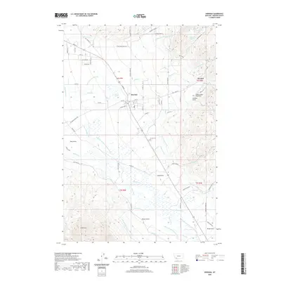
2020 Map of Sheridan
USGS Topo · Published 2020About this map
Sheridan anchors this landscape at the western edge of the Tobacco Root Mountains, where the town’s grid meets an intricate network of water management. The terrain transitions from the high peaks of the Ruby Range and the slopes of Bouge Canyon down into the productive Ruby Valley. This survey captures a highly engineered hydrological system essential to the region's agricultural life, featuring a complex array of diversions like the Vigilante Canal, Bullerdick-Hyndman-Moulton Ditch, and Schulz Ditch. These man-made channels crisscross the natural flow of the Ruby River and Wisconsin Cr, illustrating how water was harnessed to support the ranching and farming communities between the mountains and the valley floor. Near the small settlement of Brandon, the terrain is defined by features like Antelope Gulch and the Elk Hills, providing a detailed look at the geography of Madison County in the early 21st century.
Find a feature on this map
83 named features on this map. Tap any name to fly to it.
Don’t see what you’re looking for? This feature index may not catch every label — zoom into the map to look around manually.
Map Details
Editions of this 2020 Sheridan Map
This is the sole edition of this map. No revisions or reprints were ever made.
Other maps of this area

1893 · Dillon
USGS Topo · 1:250,000

1955 · Dillon
USGS Topo · 1:250,000

1957 · Dillon
USGS Topo · 1:250,000

1958 · Dillon
USGS Topo · 1:250,000

1960 · Twin Bridges
USGS Topo · 1:62,500

1960 · Waterloo
USGS Topo · 1:62,500

1961 · Beaverhead Rock SE
USGS Topo · 1:24,000

1962 · Dillon
USGS Topo · 1:250,000
1962 · Beaverhead Rock NE
USGS Topo · 1:24,000
1963 · Sheridan
USGS Topo · 1:24,000