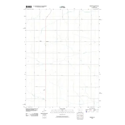
2010 Map of Sheridan
USGS Topo · Published 2010About this map
Sheridan anchors this section of Poweshiek County, situated along a landscape defined by its grid of rural roads and winding tributaries. The area is intersected by several watercourses that shaped early local navigation and drainage, including the prominent North Walnut Creek and Walnut Creek flowing eastward, while Big Bear Creek meanders across the southern border. For those researching the area's residents and communal history, both the Sheridan Cemetery and Trinity Cemetery provide permanent geographic records of the township's long-established families. The map illustrates a transition between the more established settlement at Sheridan and the open agricultural lands defined by a strictly organized road system, with routes such as Newburg Rd and 400th St carving the prairie into the characteristic square miles of the Midwestern interior.
Find a feature on this map
17 named features on this map. Tap any name to fly to it.
Don’t see what you’re looking for? This feature index may not catch every label — zoom into the map to look around manually.
Map Details
Editions of this 2010 Sheridan Map
This is the sole edition of this map. No revisions or reprints were ever made.
Other maps of this area

1954 · Des Moines
USGS Topo · 1:250,000

1956 · Des Moines
USGS Topo · 1:250,000

1957 · Des Moines
USGS Topo · 1:250,000

1968 · Brooklyn
USGS Topo · 1:24,000

1968 · Belle Plaine SW
USGS Topo · 1:24,000

1968 · Chelsea
USGS Topo · 1:24,000

1969 · Des Moines
USGS Topo · 1:250,000

1979 · Grinnell South
USGS Topo · 1:24,000
1979 · Malcom
USGS Topo · 1:24,000
1980 · Montour
USGS Topo · 1:24,000