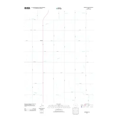
2013 Map of Sheridan
USGS Topo · Published 2013About this map
Sheridan remains the primary settlement hub in this part of Poweshiek County, situated along a north-south arterial that bisects the agricultural landscape. The township is defined by a dendritic drainage pattern where several creeks, including Walnut Cr and its northern branch, N Walnut Cr, flow eastward toward larger watersheds. To the south, Big Bear Cr meanders across the territory, its course mirrored by a strict grid of section-line roads like 370th Ave. This late-period survey illustrates the enduring nature of the Midwestern rural grid, with long-standing thoroughfares such as Newburg Rd and I Ave providing access to isolated farmsteads. The presence of Stony Cr and Elk Run further highlights the numerous small tributaries that drain this productive prairie region, showing a landscape almost entirely dedicated to cultivation and local connectivity.
Find a feature on this map
27 named features on this map. Tap any name to fly to it.
Don’t see what you’re looking for? This feature index may not catch every label — zoom into the map to look around manually.
Map Details
Editions of this 2013 Sheridan Map
This is the sole edition of this map. No revisions or reprints were ever made.
Other maps of this area

1954 · Des Moines
USGS Topo · 1:250,000

1956 · Des Moines
USGS Topo · 1:250,000

1957 · Des Moines
USGS Topo · 1:250,000

1968 · Brooklyn
USGS Topo · 1:24,000

1968 · Belle Plaine SW
USGS Topo · 1:24,000

1968 · Chelsea
USGS Topo · 1:24,000

1969 · Des Moines
USGS Topo · 1:250,000

1979 · Grinnell South
USGS Topo · 1:24,000
1979 · Malcom
USGS Topo · 1:24,000
1980 · Montour
USGS Topo · 1:24,000