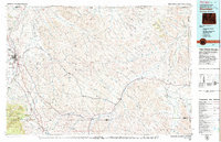
1979 Map of Sheridan
USGS Topo · Published 1979About this map
Sheridan anchors this landscape as a regional center of activity, positioned where Goose Creek and Little Goose Creek emerge from the foothills. To the west, the rising slopes of the Bighorn National Forest dominate the horizon, while the eastern plains are defined by the winding courses of the Powder River and Clear Creek. The map records a critical moment in the development of the region's energy resources, marking a Strip Mine north of town near Acme.
Find a feature on this map
55 named features on this map. Tap any name to fly to it.
Don’t see what you’re looking for? This feature index may not catch every label — zoom into the map to look around manually.
Map Details
Editions of this 1979 Sheridan Map
This is the sole edition of this map. No revisions or reprints were ever made.
Other maps of this area

1894 · Rosebud
USGS Topo · 1:125,000

1895 · Dayton
USGS Topo · 1:125,000

1899 · Cloud peak
USGS Topo · 1:125,000

1900 · Fort McKinney
USGS Topo · 1:125,000

1901 · Rosebud
USGS Topo · 1:125,000

1901 · Cloud Peak
USGS Topo · 1:125,000

1901 · Dayton
USGS Topo · 1:125,000

1903 · Fort McKinney
USGS Topo · 1:125,000

1909 · Sheridan
USGS Topo · 1:125,000

1911 · Sheridan
USGS Topo · 1:125,000