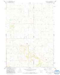
1978 Map of Sherrill Hills
USGS Topo · Published 1991About this map
Sherrill Hills dominate the central landscape of this high plains region, straddling the historic border where Wyoming and Nebraska meet. In the late 1970s, this area remained a sparse ranching environment defined by its complex drainage network. Water is the primary architect of the terrain here, from the northern flow of Indian Creek and Brush Cr to the more intricate southern systems of Antelope Creek and South Antelope Creek. Notable landmarks like Bald Butte and Turner Peak provide elevation benchmarks above the many draws and seasonal streams that carve the basin. The map records a time when the land was primarily managed for its grazing potential, evidenced by the scattered stock tanks and named creek beds like Grandma Creek and S Bar Creek that tell the story of early territorial ranching claims and family-named landmarks.
Find a feature on this map
18 named features on this map. Tap any name to fly to it.
Don’t see what you’re looking for? This feature index may not catch every label — zoom into the map to look around manually.
Map Details
Editions of this 1978 Sherrill Hills Map
This is the sole edition of this map. No revisions or reprints were ever made.
Other maps of this area

1902 · Edgemont
USGS Topo · 1:125,000

1954 · Torrington
USGS Topo · 1:250,000

1955 · Hot Springs
USGS Topo · 1:250,000

1955 · Newcastle
USGS Topo · 1:250,000

1955 · Alliance
USGS Topo · 1:250,000

1957 · Alliance
USGS Topo · 1:250,000

1958 · Torrington
USGS Topo · 1:250,000

1958 · Alliance
USGS Topo · 1:250,000

1958 · Newcastle
USGS Topo · 1:250,000

1978 · Shepherds Point
USGS Topo · 1:24,000