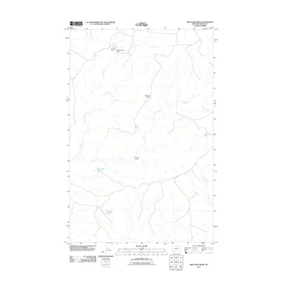
2011 Map of Shetland Divide
USGS Topo · Published 2011About this map
Shetland Divide serves as a prominent geographic spine in this portion of Phillips County, directing the flow of ephemeral and permanent waterways across the high plains. The landscape is defined by its water management features, notably the Khomeni Dam located near the northern border, which regulates the area around Saskatchewan Butte. This region demonstrates the vital importance of water storage in the Montana interior, with Dead Cedar Reservoir and Twin Snag Reservoir anchoring the southern half of the sheet. These reservoirs are connected by a network of drainages including Winter Creek, Bull Creek, and Antelope Creek, illustrating the natural irrigation patterns and terrain features like Coyote Coulee that have shaped local land use and grazing boundaries.
Find a feature on this map
11 named features on this map. Tap any name to fly to it.
Don’t see what you’re looking for? This feature index may not catch every label — zoom into the map to look around manually.
Map Details
Editions of this 2011 Shetland Divide Map
This is the sole edition of this map. No revisions or reprints were ever made.
Other maps of this area

1943 · Landusky
USGS Topo · 1:125,000

1954 · Cow Island
USGS Topo · 1:24,000

1954 · Baker Monument
USGS Topo · 1:24,000

1954 · Bell Ridge West
USGS Topo · 1:24,000

1954 · Grand Island
USGS Topo · 1:24,000

1954 · Lewistown
USGS Topo · 1:250,000

1959 · Lewistown
USGS Topo · 1:250,000

1971 · Crazyman Coulee
USGS Topo · 1:24,000

1971 · Hays
USGS Topo · 1:24,000
1971 · John Coulee
USGS Topo · 1:24,000